It was another beautiful morning so I decided to park the car and go for a walk around Greenwich. Usually I will take public transport but I'm not convinced it is safe yet so for me it had to be the car as I didn't want to do a 10 mile walk today. Parking was a problem as parking in Greenwich Park has been suspended. However, I knew of another area where I could park legally for free. Unfortunately I had forgotten that between the hours of 9am and 10am it is for residents only. A cuuning ploy to prevent commuters parking there. Eventually I found a space just off Blackheath where parking restrictions don't apply.
I walked through the park and out onto Park Vista
The houses will have good views of the park from the upper floors and with a rail station just a couple of hundred metres away, prices for these properties are anything from £1.5 million upwards.
A short walk away and you see another row of small terraced houses. These are what we called back to back houses. They would have a small backyard opening onto an alleyway where another row of houses would also open out onto the same alley. The streets were narrow with perhaps washing strung across them. These houses were very common in large cities at the turn of the 19th/20th cent. This street has hardly changed from the outside although I am sure they would be very different from the inside. Now fetching in the region of £500,000, they would need to be different!
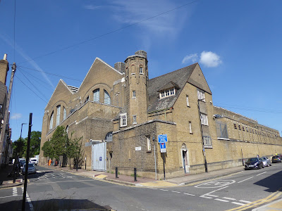
Round the corner is this huge building, Greenwich Power station. It was built to generate steam power for London's former tram network. From 1968-72, it was modernised with the discontinuation of steam generation and the introduction of gas turbines to supplement power for the London Underground. In 1998 power for the Underground was provided by the National Grid and Grenwich became London Underground's Central Emergency Power Supply which provides power in the event of partial or total loss of National Grid supplies to the Underground network.
This is the pier for the power station
Across the river you can see the highrise office blocks of Canary Wharf.
The path takes me passed the Cutty Sark. The pub used to be called 'Union Tavern' but changed its nam when the Cutty Sark ship was brought into dry dock in Greenwich in 1954.
Ballast Quay is one of the oldest parts of Greenwich riversid with some housing dating back to the 17th and 18th century.
This is the Harbour Master's Office dating from 1853. I believe it is now the Greenwich Heritage Centre.
When I walked the length of the Thames path in 2013 this was a building site so it is of great interest to me now to see all these developments finished.
The old piers still remain harking back to its industrial heritage.
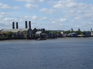
Looking back towards Greenwich I have a clearer view of the Power station
More new buildings across the river on the Isle of Dogs. No-one really knows how that part of London got its name. The most popular theory is that King Henry VIII kept his hunting dogs there. Its correct name was the Stepney Marshes but is now referred to as Docklands.

It is not an island but is bounded on 3 sides by the River Thames as you can see from this map.
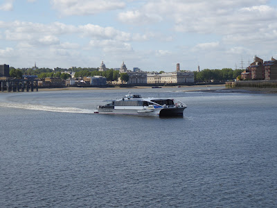
The Thames Clippers which are passenger ferries from Greenwich to the centre of London.
I retraced my steps back along the Thames path into the centre of Greenwich passing more new houses on the way.
On the right ofthe path is The Yacht, another drinking establishment which overlooks the river, currently closed because of the pandemic
This is the Trafalgar Tavern which looks glorious with all the window boxes in full bloom. The pubs are due to open next week as long as they can maintain social distancing which will be a problem for many of these old taverns.
This was the Royal Naval College built as a hospital for disabled seamen in 1696 and then used as a college. It is now part of Greenwich University. Totally deserted today.
The Cutty Sark, one of the great clipper ships which used wind power to race across the seas bringing tea from China and wool from Australia.
An empty Greenwich Market. It would normally be bustling with life at this time of the day. Let's hope it won't be too long before we can experience that once again.
I walked through the park and out onto Park Vista
The houses will have good views of the park from the upper floors and with a rail station just a couple of hundred metres away, prices for these properties are anything from £1.5 million upwards.
A short walk away and you see another row of small terraced houses. These are what we called back to back houses. They would have a small backyard opening onto an alleyway where another row of houses would also open out onto the same alley. The streets were narrow with perhaps washing strung across them. These houses were very common in large cities at the turn of the 19th/20th cent. This street has hardly changed from the outside although I am sure they would be very different from the inside. Now fetching in the region of £500,000, they would need to be different!
Round the corner is this huge building, Greenwich Power station. It was built to generate steam power for London's former tram network. From 1968-72, it was modernised with the discontinuation of steam generation and the introduction of gas turbines to supplement power for the London Underground. In 1998 power for the Underground was provided by the National Grid and Grenwich became London Underground's Central Emergency Power Supply which provides power in the event of partial or total loss of National Grid supplies to the Underground network.
This is the pier for the power station
Across the river you can see the highrise office blocks of Canary Wharf.
The path takes me passed the Cutty Sark. The pub used to be called 'Union Tavern' but changed its nam when the Cutty Sark ship was brought into dry dock in Greenwich in 1954.
Ballast Quay is one of the oldest parts of Greenwich riversid with some housing dating back to the 17th and 18th century.
This is the Harbour Master's Office dating from 1853. I believe it is now the Greenwich Heritage Centre.
When I walked the length of the Thames path in 2013 this was a building site so it is of great interest to me now to see all these developments finished.
The old piers still remain harking back to its industrial heritage.
Looking back towards Greenwich I have a clearer view of the Power station
More new buildings across the river on the Isle of Dogs. No-one really knows how that part of London got its name. The most popular theory is that King Henry VIII kept his hunting dogs there. Its correct name was the Stepney Marshes but is now referred to as Docklands.

It is not an island but is bounded on 3 sides by the River Thames as you can see from this map.
The Thames Clippers which are passenger ferries from Greenwich to the centre of London.
I retraced my steps back along the Thames path into the centre of Greenwich passing more new houses on the way.
On the right ofthe path is The Yacht, another drinking establishment which overlooks the river, currently closed because of the pandemic
This is the Trafalgar Tavern which looks glorious with all the window boxes in full bloom. The pubs are due to open next week as long as they can maintain social distancing which will be a problem for many of these old taverns.
This was the Royal Naval College built as a hospital for disabled seamen in 1696 and then used as a college. It is now part of Greenwich University. Totally deserted today.
The Cutty Sark, one of the great clipper ships which used wind power to race across the seas bringing tea from China and wool from Australia.
An empty Greenwich Market. It would normally be bustling with life at this time of the day. Let's hope it won't be too long before we can experience that once again.


