This is the B and B where Tina and myself stayed last night. We always take a photo of the group each morning before we set off. This morning because we stayed in two different places I should be posting two photos.
But due to a technical hitch, by the name of Steve, I only have the one photo of the boys, taken outside the pub where they stayed.
The South West Coast Path was just across the road from the B and B so was easy to find. The wind had dropped but it was very damp and hazy.
The weather didn't deter the surfers who were out in force this morning.


We walked around the coast for a while before moving inland.
By the side of the path was this small cottage with a very appropriate name:
'Stress Free'
We emerged from the path onto a road close to this this small chapel.
The chapel of St Anne was built in 1896 and replaced an earlier chapel situated closer to the sea. The current chapel was intended as a chancel to a much larger church that was never built. The land belonged to the Christie family of Glyndebourne who had built their holiday home in Saunton in 1895 and planned a holiday village including Saunton Sands Hotel and Saunton Golf Club.
The chapel was surrounded by Spring flowers.
We turned down a lane opposite the chapel and then along a track towards Saunton Golf Course. No golfers in sight surprisingly as we crossed the fairway.

Walking on the flat brings a smile to all our faces.
The track took us alongside a military area.We had been warned to look out for red flags which would mean a detour around the area. Fortunately for us there were no red flags in sight.

Alongside the Military Area is the Braunton Burrows Nature Reserve which is one of the largest sand dune systems in Britain. Made up of crushed windblown shells, it has been stabilised by marram grass and patchy woodland and is home to over 400 species of flowering plants. A number of small mammals have also made their home here. It is recognised as a UNESCO biosphere reserve. The Burrows takes its name from the rabbits which for many years kept the vegetation in check. In the mid 20th century the rabbit population was decimated by the disease myxomatosis which led to the estate having to be managed by grazing animals. During 1943-44, the area was used as a training centre for over 10,000 American troops before the D-Day landings. The road running through the Burrows is still known as 'The American Road'.
A dilemma about whether we crossed the reserve or walked around the edge.
This is a wood carving of an otter on top of an information board. Not sure if there are any otters around here but the track we are on is also part of the Tarka trail. The trail is inspired by Henry Williamson's novel 'Tarka the Otter'. The book was based on real places and the 163 miles of the Tarka trail follows Tarka's journey through the northern part of Devon.
The track then brought us back towards the sea. We now had a long walk following the River Taw. The tide was out leaving the boats stranded. The South West path continues along the other side of the river but to get there we have to walk a long way into Barnstaple where we will find a bridge to take us across.
The walk was along a grassy embankment
We followed the embankment in the area of The Marsh.
The information on the board explained the history of the marsh:
For many centuries this area was a well grazed tidal salt marsh. It was reclaimed in 1815 through the construction of a massive embankment and a complex system of ditches and sluices to protect it from flooding. The original salt marsh creeks were incorporated into the drainage system and the drainage channels which criss cross the Marsh, provide a network of interesting freshwater habitat with a rich and varies flora and fauna.
We followed the embankment until reaching a road at Velator Quay, built in 1853 as part of the marsh reclamation scheme. I was desperate for the toilet and was grateful and relieved to find there was a cafe just along the road. We decided to stop here for lunch. Not really hungry I made do with a delicious milkshake.
The next stage of the walk was along a disused railtrack. The railway line was in use from 1874 - 1970.
We passed the Royal Marine barracks at Chivenor which houses the RAF Search and Rescue base.
The old track has been paved which makes it hard on the feet.
The track seemed to go on forever.
Fortunately there were great views over the estuary.
A leftover from its railway days.
At last we could see the new bridge over the estuary. The Taw bridge opened in May 2007 built to reduce congestion in the town.
Tonight we were staying in Barnstaple so we needed to walk into the town.
This is the old bridge which we will be crossing tomorrow.
The old station building which is now used as a school.
The disused signal box.
The Long Bridge is the only medieval structure to survive in the riverfront area, although it has been altered numerous times over the years.

We were staying at the Old Vicarage which was a short walk away from the river.
A cycle route way marker.
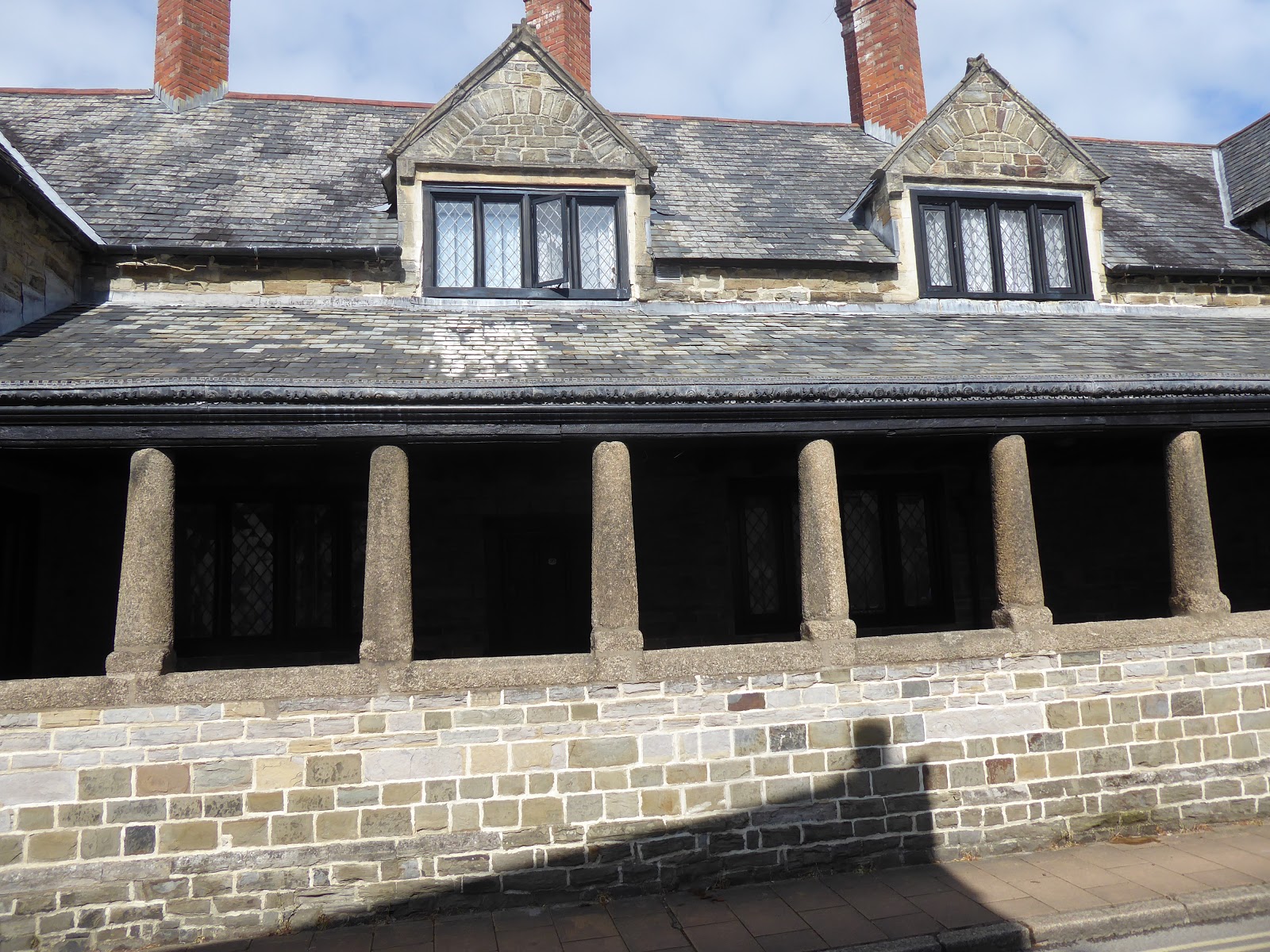
Almshouses built in the 17th century.
We could see the church a couple of roads away so assumed the Old Vicarage would be nearby.
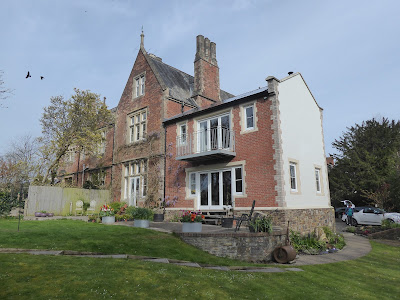
Soon we were at The Old Vicarage
with its beautiful garden.
Look at this treat which awaited us in our rooms. Everything about this place was immaculate.

I
n the evening we walked back into the town and had an excellent meal and a few drinks at the Lush Restaurant. As there was no group photo at the beginning I thought I would finish the day with one instead. Not sure why Paul looks so manic. Too much cider perhaps!


Hello the B&B looks nice and the treat delicious! I would enjoy the flat sections fo the trail too. Nice views, the church, flowers and gardens are pretty. Great views of the surfers. Nice hike and photos. Enjoy your day, have a great weekend ahead.
ReplyDeleteWhat a difference in skies from beginning to end. I love the look of that chapel.
ReplyDeleteLooks like this day was a good bit easier.
ReplyDeleteIt looks like a wonderful place to stay, and a fine day getting there, too. I am so enjoying your trek. :-)
ReplyDeleteNo mileage given for this day. It seemed to be a long one though from the number of photos.
ReplyDeleteI envy all of your experiences, the wonderful places you visit.
ReplyDeleteSo glad the wind gave you a break. Always amazed at the differences in the trails in one day. What a delightful treat awaiting you. Nice end to a long day.
ReplyDeleteStress Free is a great name for a cottage! Looks like you had another fine day of seeing the sights.
ReplyDeleteHere in the Netherlands most paths seem to be paved. So not good on the body! I think I miss that most about both Norway and Northern Ireland.
ReplyDeletePerhaps I can convince my sister about a walking trip some day. It just looks so lovely and this trip again. Envious!
Oh, I so enjoyed that. How interesting you are making these walks. I especially liked the picture of the little church and how could you not like that last photo?
ReplyDeleteI would love walking along the coastline (well, you know, if I actually could walk that far), but the military part would be scary/stressful i’d Think...what if somebody forgot to put up the flags. Your meals and lodgings always look good.
ReplyDelete