Another bright start to the day but not as warm as yesterday. We left our wonderful guest house in Porlock with a spring in our step after a delicious breakfast.
We had a couple of miles to walk before joining the South West Coastal Path.
Due to a landslip a diversion to the path meant we had to walk over a very pebbly beach. It was really hard on the feet but there was no alternative.
Lots of discussions about how we could avoid the pebbles. The only option was to return and continue along the road but that was not the safest way.
So it was a case of stop whinging and get on with it.
Finally the steps appeared to take us back onto the road into Porlock Weir.
Porlock Weir is a small hamlet with little more than a few houses and a pub.
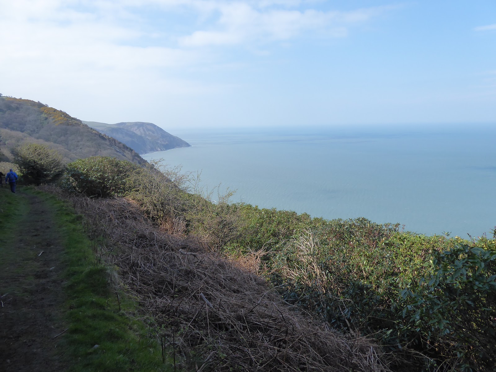
We saw lots of lambs in the fields as we left Porlock Weir.
Porlock Weir has a small tidal harbour leaving the few boats high and dry when the tide is out.
We slowly made our way upwards through the wooded slopes. Today's walk was mainly through woodland but with lots of ups and downs. Today we would be walking approx 13.5 miles with an elevation of 4000ft (1200m) on rocky paths.
At the top of the first climb we came across this double arched toll house at Worthy. The left arch is for a toll road whilst the right arch is for walkers.
A signpost directed us up a winding path through the mainly oak and holly woods.
The undergrowth was filling out with the ferns.
At the top of this hill are the ruins of a large mansion. It was owned by Lady Lovelace, the daughter of Lord Byron, who employed a team of Swiss mountaineers to construct these tunnels in the hillside. They were used by traders to come and go enabling her to visit her private beach undetected.
Evidence of old landslips gave us a glimpse of the sea beneath.
The track led us to the settlement of Culbone with its tiny church. The church is said to be the smallest parish church in England with just 33 seats. St Beuno's can only be reached by foot. The church is recorded in the Domesday book of 1086. It is thought many parts of the church date back to Saxon times eventhough the church has been rebuilt many times over the centuries.
I couldn't resist leaving the path for a few minutes to go down and have a look inside the church which was open..
The nave of the church is just 21ft in length.
Inside the church are box pews

The modern cross in the churchyard stands on a 15th century base.
I returned to the path which took us up a steep slope through Culbone Wood.
Men were at work rebuilding a dry stone retaining wall. The path had been diverted in a number of places due to landslips.
We crossed over a number of small streams flowing down the hillside on their way out to sea.
This stone cross marks Sisters Fountain. Local folklore claims that Joseph of Arimathea drank from the spring on his way to Glastonbury. We decided to stop here for lunch but it proved to be an uncomfortable, damp and cold place to stop. Jim came to our rescue and laid a towel on the cold stone for myself and Tina to sit on. Such a gentleman.
After a quick lunch we continued along the track between these two stone pillars bearing the heads of wild boars.
Here we came across workmen removing a large number of diseased trees. Whilst watching the workmen we continued down hill and missed the path. We realised it wasn't right and had to trudge back uphill to find the correct path.
A very comfortable, although damp, moss covered stone seat.
The ups and downs seemed endless today and although it was only 13.5 miles, they were very long miles. We did see some stunning views of the coastline though.
Coming down off Glenthorne Cliffs there was a coffee stop. Someone had left a cool box with drinks and snacks inside; a flask with hot water; coffee and tea with a number of clean cups. There was a pricelist so you could help yourself and then put the money in the 'Honesty box' which was inside the cool box.

We then walked back uphill again.
This is above Foreland Point which is Devon's most northerly point. There is a lighthouse on the point but impossible to see it from the track.
We walked inland for a little way and had to make a short detour because of a landslip. The church of St John the Evangelist just seemed to appear from nowhere.
Finally we could see our destination in the distance with the town of Lynmouth at sea level and the town of Lynton near the top of the cliff. We were staying in Lynmouth for the night.
Now we only had to follow the path downhill into the town.
Another opportunity for a sit down to admire the view.
Looking back to see how far we had walked.
Coming down is often as harder on the knees than climbing up.
The road into Lynmouth.
Tina and I were ready for a rest.

Once we arrived in the town our energies seemed to return as we passed a putting green and decided to play a very competitive 18 holes before going to look for our hotel.
The town nestles alongside the River Lyn

We stayed at the Bath Hotel which was OK. Not as good as our previous night's accommodation but we did have a sea view from our room. However, we were badly let down by the hotel restaurant which couldn't cope with the numbers and we had a ridiculously long wait for food (90 mins) which was only fish and chips!!!! Not a place I would recommend.


 We then walked back uphill again.


 We stayed at the Bath Hotel which was OK. Not as good as our previous night's accommodation but we did have a sea view from our room. However, we were badly let down by the hotel restaurant which couldn't cope with the numbers and we had a ridiculously long wait for food (90 mins) which was only fish and chips!!!! Not a place I would recommend.
Those views you've gotten from the high ground are incredible.
ReplyDeletePity about the hotel as Lynmouth looks very nice. The path shows and Google Maps and I can tell by the changes in direction that it is steep in parts. Wow, a water powered funicular joins Lynmouth to Lynton. I have a feeling I wrote something during a campaign to save the funicular many years ago. Maybe. St Beuno's cross looks like it only just sits on the 15th century base. The Worthy toll house is a wonderful construction and possibly occupied.
ReplyDeleteI was wrong. It was the Leas lift in Folkestone.
DeleteLove the ocean views and the tiny churches. Now I want to go on a long walk!
ReplyDeleteQuite a hike. I did like that small church, funny how they seem to he in an out o fthe way place.
ReplyDeleteI thought the toll road was a way to miss going down Porlock hill
The houses, pub, guest house and church look as if the original architecture has been well preserved.. and the water frontage of the town is a delight. But I would prefer to be hiking in light clothing :)
ReplyDeleteSome lovely vistas on the hike this day. That was a very tiny church. Did you not see the ruins of the mansion you mentioned?
ReplyDeleteYeah, only 13.5. I typed that with a straight face too.
ReplyDeleteI was tired out too by the time we got to your destination. But the views and the adventures along the way were well chronicled by all those pictures. Thanks for taking the time to post them all. :-)
ReplyDeleteHello, what a wonderful day 2 of your hike. The views are fabulous. I like the double arch toll house. The coastline, beach views and church are pretty. Happy Friday, enjoy your day and weekend!
ReplyDeleteThe only thing I envy more than your hike is the energy it takes to do it. Still thanks to your pictures and commentary, I can go along and never get winded or tired. Thanks.
ReplyDeleteI’m sure the wonderful sea views made up for the many ups and downs of the day. I love the coffee stop. I once came upon one of these on a bike path among farm fields, stocked with a big jug of lemonade by some kind farmer and very welcome on a hot summer day!
ReplyDeleteI bet it seemed a long 13.5 miles with all the detours and the pebbled beach! Shame about the hotel. We stayed in Lynton a few years back, in a self catering place, and really liked it there.
ReplyDelete